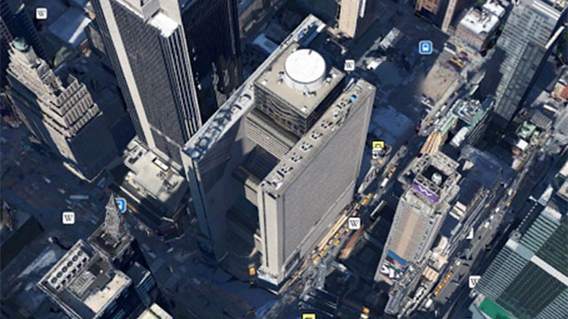
I was messing around with Google Earth last night on my phone, seeing how well it can now render 3D spaces. As you can see above, it can do New York City pretty damn well. If it weren’t for the icons, in fact, you could probably confuse that shot for a low-res photo. It didn’t do such a good job on my street, in Canberra, Australia.
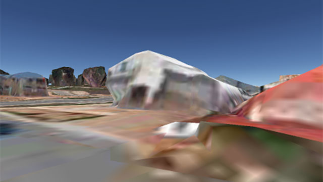
Which Google Earth seems to think is the ground in a late-90s flight simulator. And this is, I’m guessing, the SVGA version! I’d hate to see what the VGA terrain looks like.
What about you guys? Have you got the fancy 3D treatment where you live, or are you wishing your local council wold upgrade from their 486 SX33?
Comments
8 responses to “Google Has Turned My Street Into A Bad ’90s PC Game”
It’s perfectly accurate for Canberra. The houses are clearly just melting from the heat.
What suburb is this? Just checked the CBD and Nicholls and both looked a lot better once they’d fully loaded.
The maps do look a lot better when you zoom out a couple of levels but.
Franklin!
Ok. The streets I looked at looked a bit better but I definitely wouldn’t dismiss there being some bad imagery there. I think 3D mapping has some way to go until its effective in the suburbs anyway. The technology does a much better job with larger buildings which I imagine in most cases have simpler geometry or at least larger features for the cameras to pick up.
Smaller trees look bad and I fond many houses walls end up looking slanted. Still, its a nice effect when zoomed out, but zoomed in its really not a replacement for street view yet.
MY street in Canberra looks quite similar
somewhere in gunghalin?
People live in Canberra? Jks.
Is that Canberra or Arizona? lol